


وصف لـ RTKGPS+
+++++++++++++ DISCLAIMER ++++++++++++++
THIS IS AN ALPHA VERSION
I received some requests to move it to a production
version, for my point of view it works but this version
lacks some extensive tests.
However I changed it to public with this disclaimer.
IT IS PROVIDED AS IS...
WITHOUT ANY WARRANTY.
++++++++++++++++++++++++++++++++++++++
Android RTKLIB frontend.
source code can by downloaded on https://github.com/eltorio/RtkGps
Heavily based on RtkGps from Alexey Illarionov, this is a fork of his work. He allows explicitly to modify and redistribute his work only with the distribution his copyright. You'll find the original license in the "About/Legacy Info" screen. Thanks to all contributors to respect this original license clause.
Since there is no new version I reworked the code for adding some features I need:
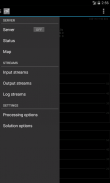
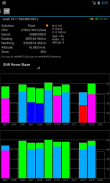
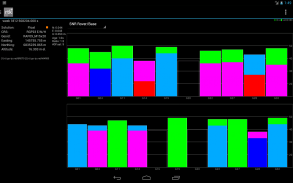
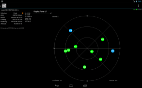
1- show the altitude in the status view.
for activating this you need to choose Height:Geodetic in the "Solution Options" view
2- send mock locations to other applications.
for activating this you need to check in the "Solution Options" view Output GPS mock locations, but this is only working if you have allowed "mock locations" in the developer settings (in Android setting).
today (in 1.0alpha13) the mock locations are not usable in the Google map API.
3- automatically upload log file or solution file to your Dropbox account
4- can generate a gpx file of the track
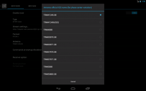
5- can display the result in ECEF, WGS84 Lat/Lon, NAD83, Lambert 93 (RGF93) or UTM (with auto zoning) coordinate system
5b- use any Proj4 projection
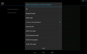
6- can display ellipsoidal height or geodetic altitude (different geoid models can be use see: https://github.com/eltorio/RtkGps for how to install a geoid model)
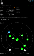
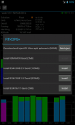
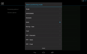
7- use any RTKLIB compliant GNSS with raw output connected via USB (ACM/PL2303/FTDI), Bluetooth, TCPIP or NTRIP
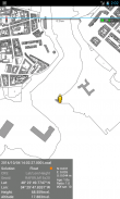
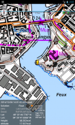
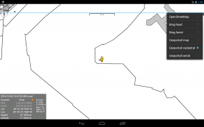
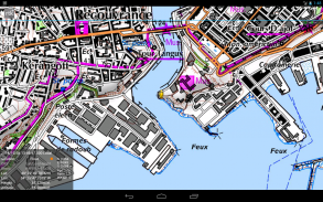
8- can display some maps coming from IGN Geoportail (cadastral parcels, satellite, roads), OpenStreetMap Mapnik, Bing (satellite, roads).
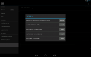
9- can download and use IGS ultra-rapid ephemeris
This software is a port of RTKLIB 2.4.2p9 developed by Tomoki Takasu (http://www.rtklib.com), if you do not know what this application is; this application is probably not what you are looking for!
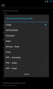
This application can compute precise GPS positions using RTKLIB algorithms (RTK or PPP) but for this you need a supported -external- GPS with raw carrier phase output.
This is not a "standard" GPS like those embedded into your phone or your car, the cheapest one you can find is something like uBlox LEA-6T .
THERE IS NO WAY to use the GPS found in Samsung Galaxy(s) nor any phone I seen.
But there is a special test mode witch use the internal GPS for testing only, obviously none of the precision algorithm found in RTKLIB can be use.
+++++++++++++ شروط ++++++++++++++
هذا إصدار ALPHA
تلقيت بعض الطلبات لنقله إلى إنتاج
نسخة، لجهة نظري أنه يعمل ولكن هذا الإصدار
تفتقر بعض اختبارات واسعة النطاق.
ولكن أنا تغييره إلى الجمهور مع هذا التنصل.
IT IS مقدمة كما هي ...
بدون أي ضمان.
++++++++++++++++++++++++++++++++++++++
الروبوت RTKLIB الواجهة.
الشفرة المصدرية يمكن عن طريق تحميلها على https://github.com/eltorio/RtkGps
تعتمد إلى حد كبير على RtkGps من أليكسي ايلاريونوف، وهذا هو مفترق عمله. انه يسمح صراحة لتعديل وإعادة توزيع عمله فقط مع توزيع حقوق الطبع والنشر له. ستجد الترخيص الأصلي في "حول / ليجاسي معلومات" الشاشة. الشكر لجميع المساهمين في احترام هذا الشرط الرخصة الأصلية.
حيث لا يوجد النسخة الجديدة المعدلة أنا رمز لإضافة بعض الميزات أحتاج:
1- تظهر ارتفاع في رأي الوضع.
لتفعيل هذا عليك أن تختار الطول: الجيوديسي في عرض "خيارات الحل"
إرسال 2- مواقع وهمية لتطبيقات أخرى.
لتفعيل هذه تحتاج إلى التحقق في "خيارات الحل" مواقع وهمية عرض الناتج GPS، ولكن هذا يعمل فقط إذا كنت قد سمحت "مواقع وهمية" في إعدادات المطور (في وضع الروبوت).
اليوم (في 1.0alpha13) مواقع وهمية ليست قابلة للاستخدام في خريطة جوجل API.
3- تلقائيا تحميل ملف سجل أو ملف حل لحساب دروببوإكس الخاصة بك
4- يمكن إنشاء ملف GPX من المسار
5- يمكن عرض النتيجة في ECEF، WGS84 خطوط الطول / العرض، NAD83، لامبرت 93 (RGF93) أو UTM (مع تقسيم السيارات) نظام الإحداثيات
5b- استخدام أي الإسقاط Proj4
6- يمكن عرض ارتفاع بيضاوي أو الارتفاع الجيوديسي (المجسم نماذج مختلفة يمكن استخدامها انظر: https://github.com/eltorio/RtkGps لكيفية تثبيت النموذج المجسم الأرضي)
7- أي استخدام الشبكات المتوافقة مع RTKLIB الناتج الخام متصلة عبر USB (ACM / PL2303 / FTDI)، وتقنية بلوتوث، TCPIP أو NTRIP
8- يمكن عرض بعض الخرائط القادمة من IGN Geoportail (الطرود المساحية والأقمار الصناعية، والطرق)، أوبن ستريت ماب Mapnik، بنج (الأقمار الصناعية، والطرق).
9- يمكن تحميل واستخدام جهاز ضبط انقباضات المعدة التقويم الفلكي فائقة السريع
هذا البرنامج هو ميناء RTKLIB 2.4.2p9 التي وضعتها Tomoki تاكاسو (http://www.rtklib.com)، إذا كنت لا تعرف ما هو هذا الطلب؛ هذا التطبيق هو على الارجح وليس ما كنت تبحث عن!
هذا التطبيق يمكن أن يحسب المواقف GPS دقيقة باستخدام خوارزميات RTKLIB (RTK أو PPP) ولكن لهذا كنت في حاجة الى دعم GPS -external- مع الناقل الخام الناتج المرحلة.
هذه ليست GPS "القياسية" مثل تلك المضمنة في هاتفك أو سيارتك، وأرخص واحد يمكنك العثور على شيء مثل uBlox LEA-6T.
لا توجد وسيلة لاستخدام GPS وجدت في سامسونج جالاكسي (ق) ولا أي هاتف رأيت.
ولكن هناك وضع خاص اختبار ساحرة استخدام GPS الداخلي للاختبار فقط، ومن الواضح أن أيا من خوارزمية الدقة الموجودة في RTKLIB يمكن استخدامها.
RTKGPS+ - معلومات APK
نُسخة APK: 1.0 Alpha 26الحزمة: gpsplus.rtkgpsتطبيقات من الفئة نفسها
قد يعجبك أيضًا...


